Chýnov Cave - Characteristics
CHÝNOV KARST
This is a rather smallish karst area bound to a formation of crystalline calcites of the Chýnov-Ledeč strip of the varied group of moldanubic rocks. It is situated in the south-west corner of the Czech and Moravian Uplands near the town of Chýnov in the Pacov Downs.The calcites, together with amphibolites are embedded in the surrounding double-mica paralic formations and the entire area is divided into several smaller blocks.Therefore, karst phenomena occur not only in the Chýnov Cave, but also near Věžná, in the Josafat Valley and especially near Velmovice.
CHÝNOV CAVE

-
The cave is situated on the southern slope of Pacova Mountain (589 metres above sea level) near Dolní Hořice, 2 km to the north-east of the town of Chýnov.
-
The cave represents a complex karst system formed in hard-grain crystalline calcites and partially also in non-karst rocks – amphibolites, erlanes, especially by corrosive activities of the water in the subterranean stream.
-
The cave lacks the classical stalactite and stalagmite decorations; however, the shapes of its areas and hues of its walls are entirely unique.
-
The cave is an important geological and mineralogical location.
-
It is Europe's largest natural winter quarters of the Natterer’s bat.
-
The cave was discovered in 1863 during the exploitation of calcite in one of the former farm quarries and was the first cave to be made accessible to the public in Bohemia and Moravia in 1868; the original romantic character of the access has been preserved to the present.
-
The total length of the areas that have been discovered so far is 1,400 m and the altitude difference (drop) is 74 m; nearly a quarter of the known corridors is flooded by water.
-
The tour of the cave is 260 m long, the vertical distance being 42 m and the average length of the tour being 45 minutes.
-
The air temperature on the tour is 5-9 °C ( ca 46°F), the air humidity 96-100 %; in winter the temperature may drop below zero in some inaccessible areas.
-
In 1992 the cave was classified in the category of a national nature monument.
SCHEME OF THE DEVELOPMENT OF THE CHÝNOV KARST
Continental waste as well as lava, ash and fractions of rocks from active undersea volcanoes settle on the bottom of a vast sea basin.
A shallow sea facilitates the evolution of organisms; the remainders of their shells settle on the bottom and thus create the basis for the emergence of the original sedimentary calcites. This sedimentation is also accompanied by volcanic activity.
The high temperature and pressure during the orogenetic processes change (metamorphose) the sedimentary calcites into crystalline calcites (marbles) and volcanic products into amphibolites.
Vast and intensive orogeny accompanied by deep magma eruptions resulted in the formation of rock groups, fractures and other tectonic disturbances.
Occasional tectonic movements and related orogenetic processes have not ceased to influence the composition of rocks, for they partially renew the original tectonic fissures and fractures and fill them with many different kinds of minerals.
The rock environment is becoming stable; the chemically aggressive water from non-karst rocks permeate the layers of crystalline calcites and form karst phenomena.
ORIGINATION AND DEVELOPMENT OF THE CHÝNOV CAVE
Although the Chýnov Cave is classed among karst caves, i.e. caves formed by water in karst, soluble rocks, it is not a typical example of this class. The difference is determined by the presence of non-karst rocks inside the calcite complex, which limits its permeability and hence also the origination, development and shapes of the underground areas. They represent an important factor influencing the course of karst formation in the Chýnov area.
Nor are the hydrological features of this karst system typical. There are no holes for the surface water to sink beneath the ground. The subterranean stream in the ChýnovCave is formed by The complexity of the corridors in the Chýnov Cave gave rise to assumptions that erosion - i.e. the mechanical influence of the subterranean stream - had been the main cause of its origination. However, discoveries made in the 1980s and 1990s supported the theory that the key factor of the formation of the cave was corrosion - i.e. chemical dissolution of calcites taking place in the freatic zone (areas permanently flooded with water). The high portion of additives in the calcite and its considerable re-crystallization help to kerb the effects of the corrosion somewhat. On the other hand, the high permeability of the calcites as well as the highly aggressive waters facilitates this process significantly. In addition, mixture corrosion takes place in the area. On its way the subterranean stream loses its dissolving capacity, which results from the carbonation. However, in permanently flooded areas the water is mixed with water permeating from the surface. Two satiated solutions of different concentrations of dissolved substances then form a new, unsaturated solution, which becomes chemically active again. This phenomenon is believed to influence the formation of many primary shapes in the walls and ceilings of the cave (chimneys, pots, holes).
A mere glance at the map of the cave reveals the regularity of the course of the cave’s corridors. They copy the geological and tectonic structure of the massif. They originated in places enabling the easy permeation of water, i.e. along tectonic fractures or breaches and in places where the calcites come into contact with non-karst rocks. Larger areas then emerged in places where ceilings had collapsed, which reached as high as the roofs especially in places of fractures and cracks. The entire cave system inclines to the north under the angle of 40–50 degrees, which is aligned with the layer of marbles. This is clearly visible on the map of the cave, where the layers are marked with different colours.
This development scheme is likely to have begun as early as the Miocene and, as the active subterranean stream has never ceased to flow through the cave, it has not stopped since then.
EXPLORATION
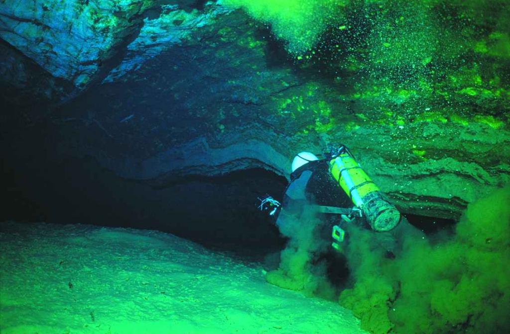
Thanks to continuing speleological research the map of the ChýnovCave gains new areas almost every year. Given the uniqueness of the location, the surveys never use blasting work and all the corridors use natural routes. The view of the Chýnov Cave system was changed substantially by exploration of the permanently flooded areas, which began in 1982. Divers of the Czech Speleological Society managed to discover vast areas reaching 45 m below the level of the subterranean stream. In following years water was drawn out of other flooded corridors, which enabled the exploration of places where intensive karst processes are still going on. Such activities emphasize creating photo documentation and mapping the underground areas. This basic exploration is followed by further applied topics in the fields of hydrogeology, mineralogy and karst morphology. The dependence of the flow rate of the subterranean stream on rainfall has been monitored ever since 2000. Many minerals have been analyzed since 1996 in co-operation with the mineralogical department of the National Museum. 17 species had never been described in this locality before. The composition of the cave air and its changes in the course of the year are also observed systematically.
In 1981, the Zoological Department of the National Museum commenced studying the bat society in a comprehensive manner. The long-term monitoring of hibernating individuals has been going on uninterrupted to the present.